|
|
|
|
Links to SPINS on Internet Archive posted by
CSRM / Jeff Asay
Some of the most frequent requests that we receive is for such-and-such SPINS book. Wx4 has PDF's for San Francisco, SF Peninsula and San Jose seen on this page, but that's it.
Unbenowst to many SP fans, CSRM slipped in a great wad of them into Internet Archive last fall. These came through the good offices of Jeff Asay, who scanned most of them from his own collection. Unfortunately, IE only offers them via streaming - no PDF's. If you have some sort of PDF editor, you should be able to make PDF's from screen shots, however.
Following is what we believe is a complete list of links to them, grouped by general regions:
- Oregon Division; includes index; 77 pages
-
- Sacramento Terminal Industry Directory, 2-1-1961 (pre-SPINS); 73 pages
- Sacramento Division, Sparks - Cobre; 47 pages
- Salt Lake Division, Paired Track Territory; 39 pages
- Carlin District, Winnemucca - Montello; 27 pages
- Oakland - Richmond; 43 pages
- Pittsburg, Zone 1-8, incl. Port Chicago, Brentwood; 19 pages
- Cal-P, incl. branches; 23 pages
- Martinez/Ozol - Mococo; 5 pages
- Oakland - San Leandro; 39 pages
- Mulford - Alviso, Hayward - Milpitas, SF Bay Drawbridge - - Tracy, San Ramon Branch; 49 pages
- as above - has index map, version 2; 28 pages
- San Francisco; 39 pages
- San Francisco, version 2; 46 pages
- San Francisco Peninsula, Millbrae - Sunnyvale; 36 pages
- San Jose; 24 pages
- Coast District, Coyote - Goldtree & branches; 51 pages
- as above, version 2; 30 pages
- Salinas zones 11 thru 18; 19 pages
- Coast District, Chular - Goldtree; 17 pages
- as above, version 2: 11 pages
- Coast main line, Santa Margarita - Gaviota incl. Lompoc & Whitehill Branches; 27 pages
- Coast main line, San Luis Obispo - Burbank Jct; 49 pages
- Burbank Jct. - Glendale; 14 pages
- Los Angeles Terminal - Yuma main line; 106 pages
- Santa Monica, Santa Paula, Stanton, Torrance, Tustin, Ventura, West Santa Ana, Lompoc-White Hills, Whittier, Wilmington, Lone Pine & Somerton Branches; State St. Line; 98 pages
- Azuza, Baldwin Park, Calexico, Chino, East Long Beach, El Segundo, Sandia, La Habra, Lompoc-White Hills, Lompoc, Long Beach & Los Alamitos Branches; Declezville; SD&AE (Imperial Valley); 125 pages
- Puente, Riverside, San Bernardino, Sandia, San Pedro, Wilmington, Santa Ana & Anaheim (SP-UP) Branches; Colton, Los Angeles Terminal; 120 pages
- Phoenix Subdivision, Welton - Magma; 51 pages
- Valley main line, Saugus - Burbank Jct; 9 pages
- Bealville - Mojave - Palmdale; 23 pages
- San Joaquin Div. Listing of Industries and Tracks; 78 pages
- Chowchilla - Saugus main line; 42 pages
- Lone Pine and Oak Creek (Creal) Branches: 7 pages
- as above, version 2; 3 pages
- San Joaquin Division: Arvin, Oil City, Buttonwillow Branches; Sunset Railway;
16 pages
- Exeter Branch: Fresno - Famoso, Exeter - Goshen Jct; 24 pages
- Coalinga & Stratford Branches; 6 pages
- Riverdale (Burrell) Branch; 3 pages
- Clovis Branch & Pinedale spur; 9 pages
- Kentucky House Branch; 6 pages
|
|
|
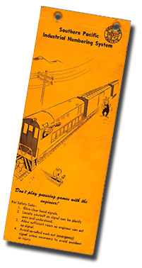
On any large railroad, operating crews need a roadmap of sorts to figure out where customer spurs are located. Beginning in the early 1970' SP's method was SPINS, the Southern Pacific Industrial Numbering System, which had evolved out of the earlier PICL, Perpetual Inventory Car Location, PICL, or "pickle".
SPINS was also known as the Zone System. Customers spur tracks were given numbers and grouped into Zones - discrete geographic entities within a given switching district, which were also identified numerically.
For operating crews, the vital component of the system was the SPINS Book, which consisted of a list of customers sorted by Zone with corresponding maps showing customer locations. Ned F. Reed ("NFR" on the maps)of the Western Division Engineering Office in Oakland created most of the initial maps for the Coast (also Western) district books listed below
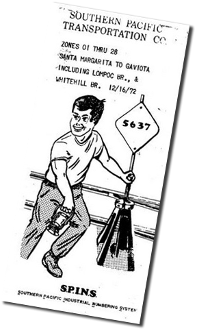
As a measure of their value, any self-respecting switchman would not be caught dead carrying a timetable or rulebook, but just the opposite held true for SPINS Books. Out in the Zones, standard engine foreman gear included a switch key, lantern and a company-issued orange plastic timetable cover containing a switch list and SPINS Book. Even the most encyclopedic of old heads occasionally found himself stumped by a SPINS number, and could be seen sneaking a peek inside THE BOOK at his locker before heading out the shanty door.
How many rules violations can you spot on this SPINS Book cover? >
|
 |
|
 Note the Fairbanks-Morse switcher.
|
SPINS Books:
- SPINS Book Covers: a selection thereof
- Generic Preface: some books had minimal explanatory information up front, but this one is more extensive
- San Jose: includes the Coast Main from the Santa Clara area to IBM, south of Lick; the Lick Branch; the Mulford Line in Santa Clara; the "Western" (Milpitas) Main in North San Jose; the Vasona / Permanente Branches
- San Francisco: includes trackage fom San Bruno to downtown San Francisco; the Hunters Point Lead; the former San Francisco Belt in South San Francisco; the remains of the old Ocean View Main - the San Bruno Branch and the switching lead that headed from the Townsend passenger yard towards the former SF&SJ roundhouse area on Harrison St. Some of the maps date from 1960's PICL days.
- San Francisco Peninsula: Coast Main from northern Santa Clara to Millbrae, including the lead to Redwood Harbor; the Dumbarton Main from Redwood Jct. to the Dumbarton Bridge's western approach
- Santa Cruz, Olympia, Davenport Branches: link to PDF on friend Robert Bowdidge's Model Railroad Pages
- San Antonio Division - San Antonio and Beeville, Kerrville Branches - courtesy Kenneth W. & David Moore
Other SPINS:
|
|
|
|
|
