
"Whaddaya mean that I don't own the right-of-way?"
(rev. 10-14)
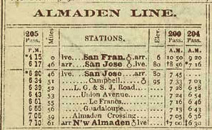
Right: snippet of SP February, 1886 timetable
When Southern Pacific abandoned its Almaden branch line operations in segments during the mid-1930's, the rights-of-way (ROW) passed through lightly-populated agricultural land that was of little worth in those Depression-era times. The trains saw no business on the majority of the New Almaden run after World War I, Frank's nephew, Jack Pfeiffer claimed that SP had continued operating the once-a-week branch trains after then specifically to hold on to the franchise in the hopes that the ROW would have future value as land. The Depression made that a luxury.
SP apparently did not put much, if any, effort into selling these narrow strips of land. Local farmers and orchardists likewise gave little thought about the matter, and for no good reason, many assumed that once the rails were gone, the ROW had reverted to the them . Thus, they proceeded to plow it up for their own purposes. Such automatic repossession was not necessarily the case, however. For the owner of the land adjoining the ROW to have any claim, the original deed of sale required a reversion clause stating that South Pacific Coast Railroad (later SP) would surrender title should the line be abandoned.
After World War II, Frank Pfeiffer began selling real estate and somehow caught wind of the fact that some local farmers were essentially squatting on chunks of the former South Pacific Coast ROW. He also learned that SP's holdings extended further than the tracks ever penetrated. Back in the 1880's, the South Pacific Coast Railroad had purchased real estate in the Calero Valley as part of James Fair's grand plan to connect with the Denver & Rio Grande in Utah. The SPC tracks, however, only made it as far as a terminus on the southeast side of Harry Road, on the other side of Los Alamitos Creek from SP's New Almaden Station. According to Uncle Frank, SP still owned a sporadic two or three miles of ROW further up the valley.
With this in mind, Frank, along with his cousin Amy Melonson, bought up all of the SP land that they could afford. Then Frank, the agent, would approach the squatters, who had been merrily farming the land for a decade, and apprised them of the situation. One can imagine the farmers' reaction, "Whaddaya mean that I don't own the right-of-way?" Despite his high-handed maneuvers, Frank was a patient, mild-mannered and effective salesman who had no interest in, or money for, lawsuits. He simply made it clear that he had the upper hand - he could always sell the land to somebody else. He claimed that he eventually unloaded their purchases at a profit.
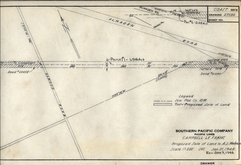
This SP Engineering Department drawing shows the proposed sale of land on either side of Almaden Crossing, where the ex South Pacific Coast branch from Campbell crossed Almaden Road. (The rails remained embedded in the crossing pavement until Almaden Road was widened into the Almaden Expressway in the early 1970's.) The buyer of record was Amos "Amie" Melonson, Frank's cousin-partner. The Pfeiffer and various extended family - Skuse, Estrade, O'Day, Streigle - constituted a huge presence in the Almaden Valley, farming/ranching much of the land along Graystone Lane (including the former Goodrich sandstone quarries), which ran next to the broad gauge tracks (the current Graystone's north lane runs on top of the former tracks). It likly was somebody in the family that tumbled onto the land situation, and alerted the others. Note: The entry on the drawing that says "To Le Franc" is in error. Campbell and Le Franc are in the same direction, timetable west of the parcel. The entry should have stated "To New Almaden".
As mentioned above, in the early narrow gauge days, the narrow gauge line crossed the standard gauge branch a little north of the New Almaden station, then continued on to a terminus on the south side of Harry Road. Further below is a Wx4 photo of the crossing site in 1974.
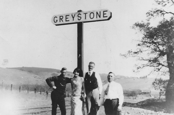
Frank Pfeiffer's shirttail relative Amos "Amy" Melanson, right, posed in front of the Greystone station sign on the broad gauge branch, above the SP/SPC crossing / junction, ca. 1930, looking roughly east. Also shown: Andy Nopper (left), his girlfriend - name unknown, and Rudy Nopper. By this time, the sandstone quarries, had been idle for more than two decades and Frank had a small vineyard in front of his house about a half mile down the tracks. Wx4 Collection
(click on the image for a Wx4 HumongOphoto™)
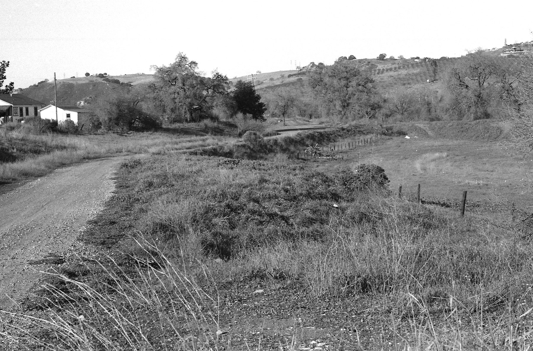
The photo, shot in early 1974 when the Almaden Valley was in its initial throes of suburbanization, looks northward along the broad gauge ROW. The tracks crossed each other where the trees cast a shadow over the broad gauge, to the right of the house, and the narrow gauge continued on across Alamitos Creek on the embankmet at upper right. The narrow gauge headed towards Almaden Crossing and Campbell to the left of the shadow, up a driveway behind the farmhouse. By the time of the photo, the embankment's remains only ran for 50+- feet before intersecting with the flood control berm showing to the right of the bike path down the narrow gauge embankment. This short segment was the only "pure" narrow gauge ROW left. Flood projects and orchard cultivation had erased the line on the other side of the bank, and everything else was standard-gauged. Even money says that the farmer who lived in the house in the 1940's was one of Uncle Frank's 'customers'.
It would be hard to find this exact photo location today. Best guess, between Queenswood Way and Brooktree Court, about two-thirds of a mile north (as the crow flies) of McKean Road. Queenswood probably was plowed directly through the SPC embankment. The flood control berms in the area were extensively re-aligned at the same time, with the depicted section probably moved further to the right (east). Homes now fill up the rest of the scene.