|
Shortlines
xxxx
Part of Wx4's "The Past Less Traveled" series: Sorting out the veracity of the c.1897 "Morton Map"
latest revisions, additions and admissions: 9-29-2022; 12-12-2024, 1-8-2026 |
||||||||||||||
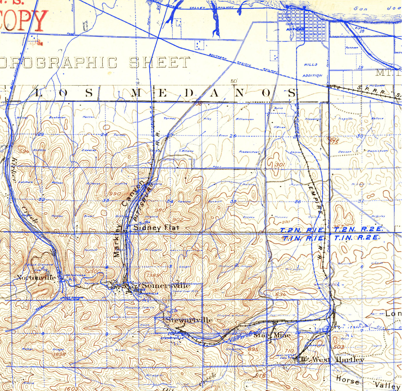
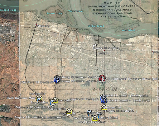
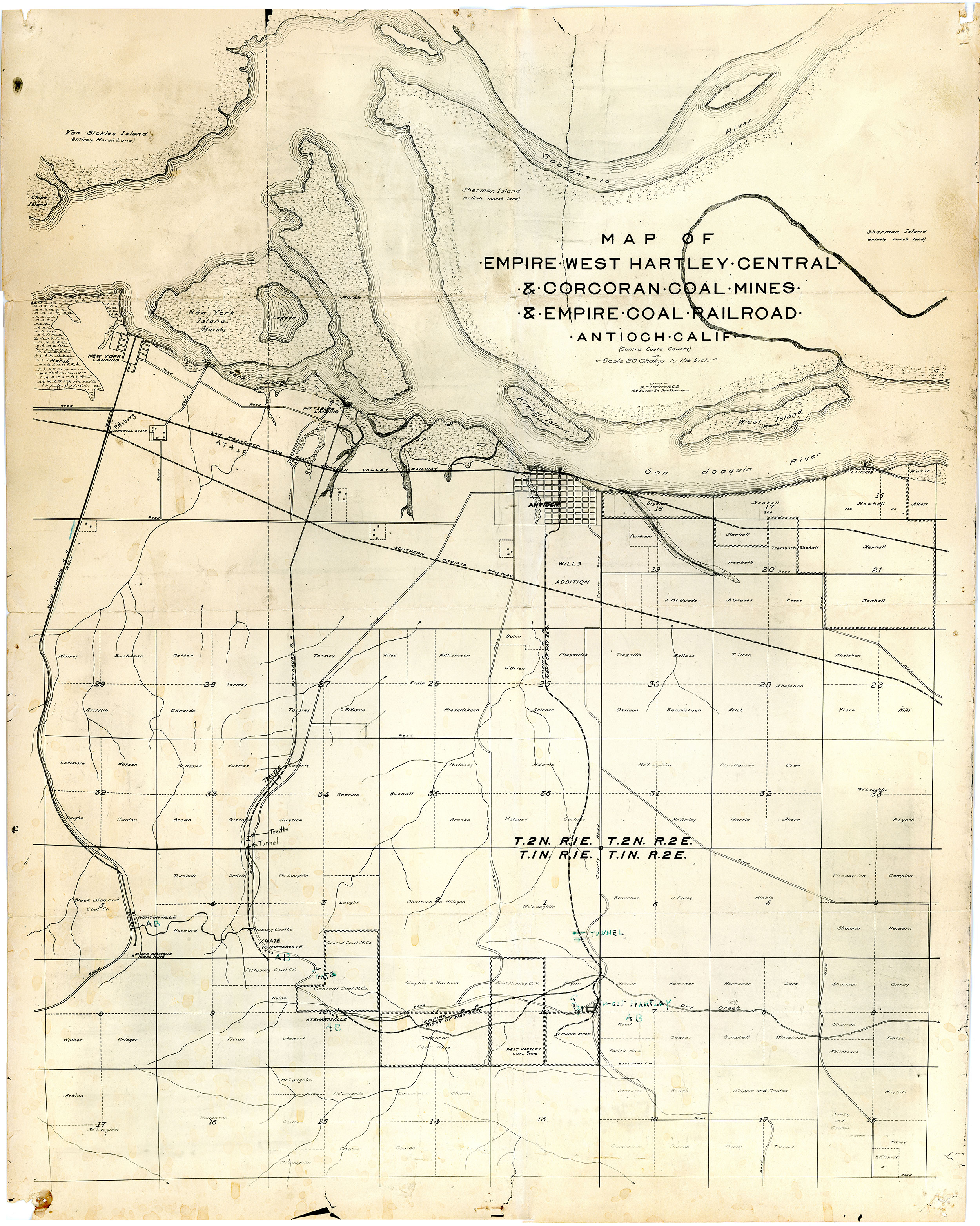
| Shortly after the Civil War, the hills south of Antioch, California became populated with three short railroads that served the area's small collection of coal mines known today as the Mt. Diablo Coal Field. High grade coal fields of any appreciable extent did not exist in California, thus creating a market opening for the area's inferior lignite and sub-bituminous grade products. They prospered into the 1880's, but by the Turn of the 20th Century they were largely done. Plenty has been written over the years about the mines and their railroads, so only bare historical outlines of the subject railroads is shown towards page bottom. A substantial amount of conflicting information still remains to be sorted out - such as the cessation date of Black Diamond Coal Mining Company's railroad - so we will post new data as it becomes available. The "Morton Map" (our appellation) seen below first appeared on Wx4 nearly two decades ago and we merely assumed that it was reasonably accurate, without ever investigating its veracity. (note: The map image is now linked to a much higher resolution rendering than the one offered until now.) Wx4 friend Evan Josa recently happened upon the map and decided to do what we had not done: compare it with USGS topos, and ultimately, trace the route atop Google Earth. He placed his results in a .kmz format file which can be read by most any mapping program. In addition to Google Earth (both online and standalone app) Wx4 has tried it with good results in Garmin BaseCamp. His results appear further below. In summary, Wx4's treasured map did not hold up well to Evan's scrutiny. | ||||||||||||||
 |
||||||||||||||
|
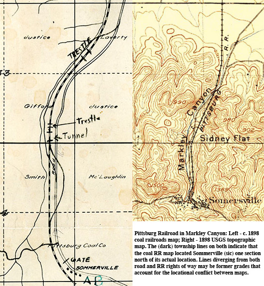
In fact, parts of the Morton map are so inaccurate that they beg the question that we previously never asked: Why was the map ever produced in the first place? Unfortunately, even though it does seem to be contemporary to the railroads' existence, a general paucity of clues has thwarted our attempts at a definitive answer. The map's cartographer, R. F. Morton, a San Francisco Civil Engineer in the 1890's and early 1900's, apparently traveled in mining circles. In 1898 he was a partner in what was cryptically identified as the "Keystone D. Co." in a list of mining start-up companies (which listed its capitalization at $100,000, with $25 in actual subscriptions). The "D." likely stood for Drilling, while Keystone name may have referenced a tiny coal field then existing in Amador County. The same year a fellow named C. M. Wilson attempted a comeback If the data shown on it were absolutely true-to-the-minute, then we can date the drawing to 1897-8. Santa Fe acquired the 1897-completed the shown San Francisco and San Joaquin Valley R.R. line through Antioch in 1899. Empire Coal Mine & Railroad Company closed in 1897 and was soon purchased by a fellow named C. M. Wilson, who attempted a comeback in 1898. In the process, he renamed its conduit as Antioch Railroad. Perhaps significantly, unlike the other two lines, the map shows the width of Empire RR's right of way, 66 feet. This at least suggests that the map may have been commissioned by Wilson in 1897-early 1898 during the initial planning stages of the mine's comeback. The map's creator, R. F. Morton, a long time San Francisco Civil Engineer, apparently traveled in mining circles. Coincidentally, in 1898 he was a partner in what was cryptically identified as the "Keystone D. Co." in a list of mining start-up companies (which listed its capitalization at $100,000, with $25 in actual subscriptions). The "D." likely stood for Drilling. Associating the map with associating this map with Wilson is that it does not show Empire Railroad with any reasonable precision, as we now know thanks to Evan's efforts. In particular, the central portion of the depicted route lazily varies from the 1898 USGS topo map below and Evan's real-world rendering, and the total omission of the branch line serving Star Mine, which had opened only in 1893. It is as if he scouted the Empire line through the lens of a whiskey bottle, and drew up the map while teetering on a an Antioch barstool. |
||||||||||||||
|
||||||||||||||
|
Rights of Way on 2021 Google Earth .kmz map overlay by Evan Josa
|
||||||||||||||
|
Early-on in his study of the Morton map, Evan could see that parts of it diverged from the 1898 topo to the extent that he felt compelled to create a map of the railroads that stood in better accord with reality. He managed to trace the actual routes to a high degree of accuracy by studying the Google Maps satellite imagery and Historic Aerials photos, which provided the findings seen on his overlay. Though largely successful in uncovering the actual rights of way, he admits that he was unable to find the location of the original Hartley mine, noting that Ward in Western Railroader (see biblio) may have been in error about its location.
|
||||||||||||||
|
New 9-29-22: Clyde Underwood's 2018 Visit to West Hartley, Star and Empire Mines / Railroads
|
||||||||||||||
|
1886 irrigation map:
|
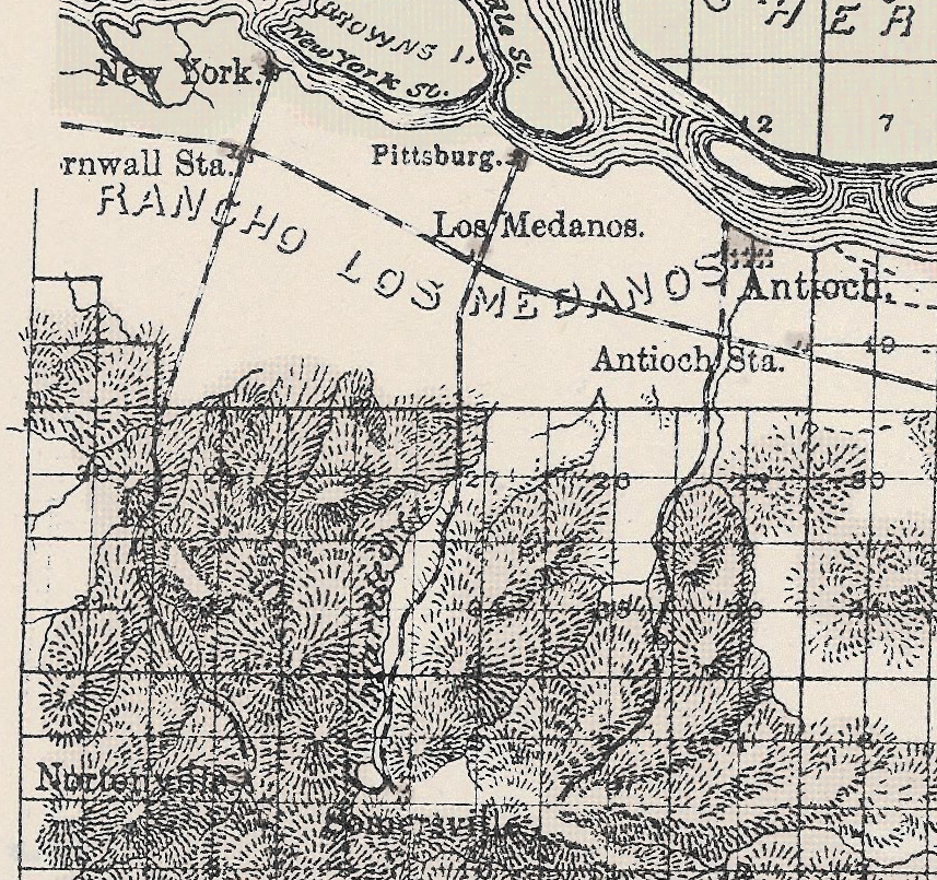
California State Engineering Department put out a series of irrigation maps of the San Joaquin Valley in 1886. "Sheet No. 1, Northern Portion..." depicts the three railroads, but without enough detail to be of much use in the present exercise. It does show a swing to the west at the end of the Pittsburg Railroad at Somersville that is unrecorded on the other maps. Evan Josa found evidence of this, which is reflected on his Google Earth overlay, above. It may have been narrow gauge mine trackage. Click on the thumbnail for a large (cropped) image that has been desaturated to make it more readable. The full map is available for download at the David Rumsey Historical Map Collection. |
(click on the map for an enlarged version) |
||||||||||||
|
Company Overviews
|
||||||||||||||
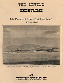
| He reeled us in like flounders... For about 15 years, Wx4 was an unkowing victim of a bit of historical mischief perpetrated by the late, well known-railroad historian Ted Wurm, much to our chagrin / delight. We fell for it hook, line and sinker. In 2018, a compassionate friend of Wx4, Clyde Underwood, set us straight. In 1988, a fellow named Teodoro Gusano III penned a 12 page booklet, The Devil's Shortline, as seen above. Within it, he related how Antioch Railroad (ex Empire Railroad) was folded into a new tourist operation, Mt. Diablo & San Jose Railroad, which subsequently expanded well beyond the slopes of its namesake mountain. Copies of his work are rare outside of institutions, so in the absence of one, we relied upon quotations from a more recent master's thesis in mentioning the MD&SJ in our little Empire synopsis, (as revised!) further above. Well, the short of it is that Teodoro Gusano (loosely) translates into Theodore Wurm, and his railroad was a complete fabrication. When Clyde let us in on the joke, we were floored. Laughter-induce hyperventillation can do that to people. Clyde also pointed us towards an page at PacificNG.org that lays out the whole sorded affair, although after being once burned, we absolutely no way will vouch for its authenticity. Unfortunately, we never met Ted, but we have encountered ample testimony that he was well loved (and a good historian - we have his books). His publisher, the late Robert L. Hawley of The Ross Valley Book Company is equally missed, we are told. We close this confession with a warning: Mr. Wurm's work is an inspiration. E.O. Gibson, 11-01-21 |
||||||||||||||
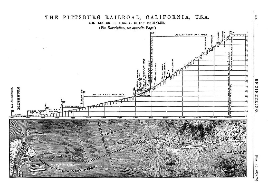
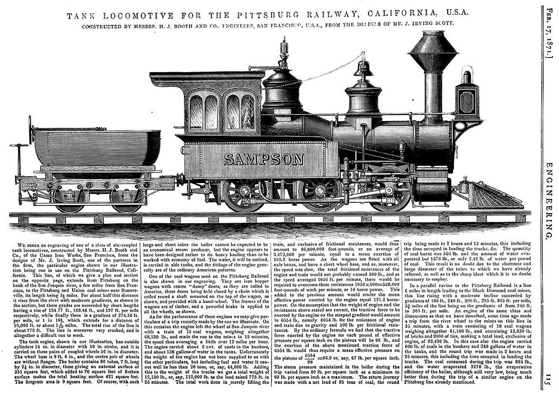
| NEW 1-8-26 - A major find: Ken Martin has forwarded these two pages that he extracted out of an 1871 issue of the journal Engineering. As you shall note, there is a wealth of heretofore unknown (to Wx4, anyway) data and especially a map and profile that puts R.F. Morton's questionable efforts to shame. Thanks Ken!
|
||||||||||||||
|
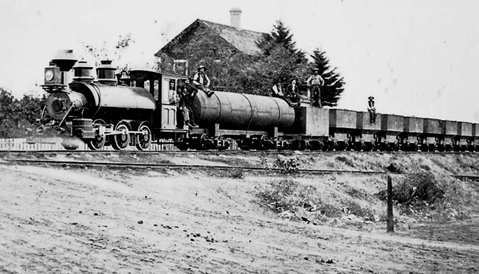
Above - Empire Coal & Railroad Company's Jenny E. Belshaw and train sit at the foot of F Street in Antioch in 1881. Wx4 collection; original photo now in the Black Diamond Mines Regional Preserve collection, and also appeared in the book Black Diamond Mines Regional Preserve by Traci Parent and Karen Terhune; Charleston, S.C.: Acadia Publishing, 2009 |
||||||||||||||
Selected Sources:
|
||||||||||||||
 |
||||||||||||||